Last night, I heard something by my head. It woke me up and when I moved, I could hear it running through the woods. I listened for a while and determined that it did not sound like a bear, too nimble, so I thought that it was probably a deer. When I woke up in the early morning light, my suspicions were confirmed. A couple of campers set up near us after dark, and this morning the deer is next to one of their tents nibbling on their pack. The deer come around and lick the salt deposits from our sweat and other bodily liquids that we may leave nearby. We cover our packs with our rain covers to prevent direct nibbling but the deer by my head may have been sniffing around for the salt smell. This deer is not afraid and doesn’t even move as I go to water a bush. When I come back, one of the other campers chases it away, but it soon returns again. We start to pack up for an early start as we have 7 miles of all uphill climbing to start out with. We don’t know how much of this is exposed to the sun so we try to get an early start. The other two hikers are also slowly starting to move. Carol talks with them briefly and they go by the trail names of Hokie Pokie and Apparition.
We leave camp at 0630 and start the long morning climb. In a mile we pass Myrtle Flat and a nearby creek.

Hmmm
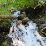
There is a sign laying on the ground which says Poison Spring is 5.2 miles. I think we will skip that one. We are also 52 miles from Lassen National Park. A short while later, we pass a large pile of bear S**t on the trail. That answers the question of do they s**t in the woods. The answer is yes and apparently with no trail etiquette. This sighting also alerts our senses and we make a little more noise for the next .5 mile or so. We then come to a large creek crossing that is a bit of a complication to cross. We manage to get across on a boulder and a large log without getting our feet wet, and stop to filter some water to drink. We are 2.3 miles from camp and have already gained over a thousand feet in altitude. After a quick snack and drink, we are back at it, climbing once again. We come to Chips Creek which is quite wide, flowing strong, and doesn’t seem to have a good place to cross. Carol thinks she has found a spot but I do not like it. Seeing nothing better, I try to cross and my foot slips on a slippery rock and I slide in up to my thighs. Time to retreat and now that I am already wet, I move to a slower moving spot and wade across. Carol is determined to keep her feet dry but finally agrees with my assessment that the potential crossing to do so is by faster current and could be a bit dangerous if she falls in. She ends up wading like I did so we now both have soggy feet, although my pants are wet quite a bit higher up than hers.

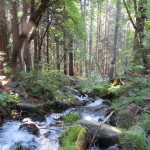
Chips Creek From Above
Over the next mile and a half, as we climb above Chips creek, we cross at least 4 more streams which all required us to get our feet wet. So, in the long run, wading across Chips Creek did not matter as we were getting wet one way or another.
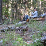
We keep climbing and break out of the forest onto a ridge with some switchbacks. This is the first view we have had today. The switchbacks cross another creek and then we enter a meadow where the trail flattens out. It would be a nice spot for a break, but we are determined to get more of the climb done and make it another 2 miles to Andesite Spring for lunch. The mile long meadow is a nice break for our legs but then we are back to the uphill again. At least we are back out of the sun and into the shade of the forest. The altitude we have gained has also helped with the temperature. I am guessing we are around 75 to 80 degrees and in the shade, it is not too bad. This last mile to the spring climbs about a 1000 feet and we slow down as the grade steepens. We make it to the spring at 1135, five hours and 6.9 miles from where we started. Not exactly a record breaking pace, but from here we only have a little more climbing to go. More importantly, we get to have lunch and drink as much as we want from the cool spring. As I look at my map, I discover that Andesite Spring is the aforementioned Poison Spring, on the map. So, hopefully, our bones are not discovered here after we drink.
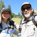
We enjoy our PBN lunch and lounging in the shade, perhaps a little too much.

Our Shady Lunch Spot
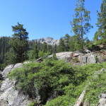
As we pack up, a deer walks by us on his way from the spring. It is after 1:30 before we start out again. The first mile consists of a 500 foot climb to the high point of our day at just under 7100 feet. As we top, the last hill, we get a view of Mount Lassen, which is definitely getting closer, yet is still over 50 miles away. We are soon caught up by two guys known as the Scottish Brothers. They are, as their name implies two brothers, from Scotland. We chat briefly and then we pass them by later as they have stopped to get water at Frog Spring. The hiking from here is definitely easier, terrain wise, but by this point our legs are functioning on low efficiency. We walk through a jumbled landscape of boulders and scraggly and dead pines. Our bodies are on autopilot as we trudge through the landscape. We do get back into the forest and have a slow descent toward Cold Springs. When we get there, the springs are 100 yards off trail and near a dirt road so Carol goes to scout if there are camp spots nearby while I wait with the packs. She returns and says there are some spots, just as the Scottish Brothers arrive at the trail junction. We bring our packs down and claim our home for the night. The spring is actually coming from the ground and through a pipe into a large horse trough. We are able to get our water right from the pipe but still filter as a sign says it is not potable.
The Scottish Brothers decide to set up camp here also. As we are having our mashed potato dinner, a day hiker from Chico stops by and chats with us. He has come up to bird watch and photograph birds but says he did not see many. He heads to his car and we dig into our treat dessert of the day, Oreo cookies. So very good and tasty. Our stats for the day are 13.5 miles at an average pace of 2.2MPH. The first 7 uphill miles, we were averaging 2 MPH which I think is pretty good. We had over 3500 feet of elevation gain today and are currently camped at 6480 Feet. We are very happy to have completed the infamous Belden descent and climb.
-

- By Myrtle Flat
-

- In the Woods? They Do
-

- Creek Across Trail
-
- Where We crossed
-
- Pit Stop Creek
-
- Pit Stop Filtering
-

- Above Chips Creek
-
- First View of Day
-

- Reflections
-

- Pretty
-
- CNC in the Meadow
-

- Yellow Palooza
-

- Mount Lassen
-

- Jumbled Landscape
No Comments Yet